
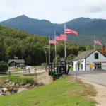
Climb to the Clouds
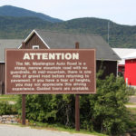
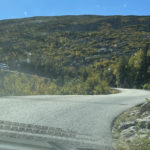
The sign warns that the Mount Washington Auto Road is a steep, narrow mountain road with no guardrails and some gravel. If we have a fear of heights, we may not “appreciate” this driving experience and guided tours are available. Since we have driven on all sorts of roads in all sorts of conditions, let’s do this!
Since my photo galleries are messed up, please use the back button to return to the main page from each thumbnail photo.
To start at the beginning of this series, visit Fall for New England 2021.
We’re Not Babies!
The fear-of-heights-part of that opening statement had Jim a little nervous – but we’re not babies! We’ve driven up Pelican Butte and in the Big Horns, Rockies and Smokies. We’ve driven the road to Hanna (into the morning sun with a dirty windshield) and the road to Oatman. We’ve driven back to Iowa in feet of snow, torrential rains and after ice storms.
Many times we’ve driven on the edge of a shear cliff called Blizzard Gap near Winnemucca. Jim headed down that one in snow one December. That was before my time (thank goodness) because a return trip in the spring would’ve been necessary to retrieve me! They put the chains on the front tires for that portion of their trip.
“On Hwy. 89 from Prescott to Wickenburg there’s another fun road called White Spar by the locals. According to the guy that posted this video, “Route 89 is arguably one of the best motorcycle roads in Arizona!” If you watch the video, at one point you can see where the oncoming lane disappears, and for a stretch this highway becomes a double-decker, returning a ways later. If you can stomach the video, you are truly ready for the drive, because it’s not nearly as stressful on four wheels.” ~ from Red Rocks to Sin City
We headed off on our adventure confident in our abilities to handle this measly 7.6-mile trek.
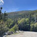
So Far So Good!
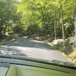
We started off like any other road trip. Lush green trees and curvy roads. This is going to be fun and the views will be fantastic! Jim’s palms had already begun to sweat.
So far so good. Nice big boulders to keep us on the road with not much drop-off, and the sky was absolutely beautiful. Jim could not look at the sky, he was looking at the road!
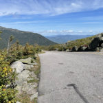
Stay in Your Lane!
OK, we’re getting a little more serious here, but the sky is so beautiful! There’s oncoming traffic? Hope those idiots stay on their side of the road!
No More Pics till the Top
Camera’s in the back, but trust me we were on the edge at many points. I had my window down so I could lean out and give Jim just a little more warning about oncoming cars. I may not have been pushing an imaginary brake, but I was leaning and hanging on to the side of the car so tightly that my arm was cramping up!
There were certain areas where there was a TAD more room for two cars to pass by each other, and our timing was pretty good with those. I’ll have to admit this is getting a little unnerving and Jim is not happy!
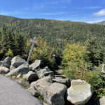
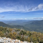
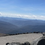
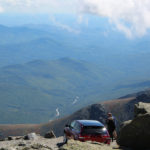
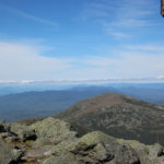
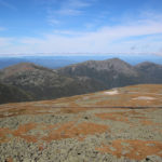
Once we got to the top, I took the video below and hopefully it’s not blurry from my shaking hands. Now THAT was an experience! Of course the views from the top made it all worthwhile – for me anyway. Not so sure about Jim.
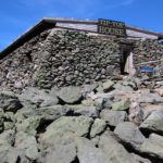
America’s Oldest Man-Made Attraction
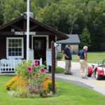
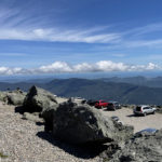
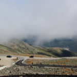
Open to the public in 1861, this privately-owned road climbs 4,723 feet (in 7.6 miles) from the base area, and reaches more than a mile into the sky to the highest point in the Northeast (6,288 feet). Bring a jacket (or coat) since temps drop considerably and winds are intense up there. We picked the warmest and least windy day of our stay in Bartlett to visit, and it paid off. Clear skies through most of our stay made this a wonderful experience (except for the drive up lol).
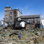
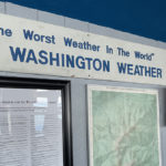
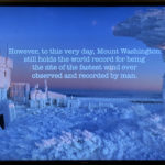
Extreme Weather Museum
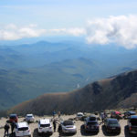
At the summit is Mt. Washington Observatory and its Extreme Weather Museum, which was free with the fee at the entrance. Very interesting stuff in the museum with some great photos of some EXTREME weather, that’s for sure. It takes very dedicated people to be able to withstand these conditions all in the name of science.
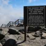
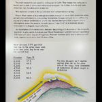
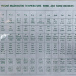
Be sure to read some of the info in the photos below with temperature, wind and snow records. Turns out we were pretty lucky on this gorgeous day since Mt. Washington is in the fog more than 300 days a year!
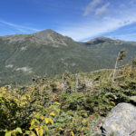
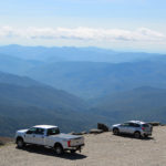
More Vantage Points
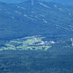
We could see the bright red Mount Washington Hotel (photo below), down the mountain about 3,000 feet! Of course it took full extension of my zoom lens and with the whipping wind, the photo is not good. I have somewhat better photos of that fabulous place at the link. In the other photos just below you can see the main road and the Mount Washington Cog Railway tracks.
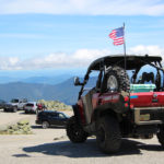
Other Ways to the Top
In the video just above, folks are almost to the summit using one of the many miles of hiking trails that traverse the mountain. We didn’t look into the trails, but talked to several folks who were finishing their climbs and the time it took ranged from four- to twelve-hours, so there must be shortcuts or less rambling routes. I don’t care how treacherous the drive was (for Jim), but it was better than walking – especially in that rough terrain, with ever-changing weather conditions!
“Mount Washington is the highest point in New England and the highest peak in the White Mountains of New Hampshire. Often called the most dangerous small mountain in the world, Mount Washington is recommended for experienced hikers and climbers who can handle significant elevation gain.” ~ READ MORE at alltrails.com
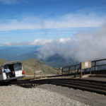
If driving (or being driven) or walking does not appeal to you, perhaps the Mount Washington Cog Railway is your cup of tea. I’m assuming that the folks who hiked up may want a ride back down? I know I would, although I would have preferred the ride up.
Top Speed at 130 Miles per Hour?
Click the link for a video of the Subaru Mount Washington Hillclimb – better known as the Climb to the Clouds. In August of 2021 Travis Pastrana set a new record in a race up Mount Washington, outdoing his 2017 record with a jaw-dropping time of 5 minutes and 28.67 seconds. It took us an extra half hour. I can’t even imagine!
“For anyone who has driven the 160 year-old Mt. Washington Auto Road, this blisteringly-fast time to reach the summit is almost inconceivable. Typically travelers go between 20-25 miles per hour on the road as there are no guardrails on the narrow asphalt and gravel surface that features dramatic drop-offs into the Great Gulf Wilderness. Pastrana averaged 80 miles per hour on the 7.6 mile course with a top speed in excess of 130 miles per hour.”
What an amazing adventure this was, but now we have to get back down! We were instructed to use low gear on our descent to save our brakes and keep us at slower speeds. Jim’s palms have already begun to sweat!
Next up: New Hampshire Bridges
Happy trails,
Barb


