
Snowshoes to Sunshine
In order to make this trip more affordable, our itinerary revolved around timeshares. With no timeshares in southern Utah and northeastern Arizona and only 2-3 hours between Vegas, Zion, Bryce, Page, Monument Valley and Canyon de Chelly, we scheduled in a hotel night with each move. That plan worked out pretty well – in fact we ended up getting to Page early, but only because of the crummy winter weather that shortened up our visits in both Zion and Bryce. In nicer weather we would have needed at least another day at each park. I’m thinking next trip we may rent an RV to explore Utah, and give it the time that it really deserves.
As we continue our nine-week road trip, this afternoon we’re leaving Bryce Canyon, Utah en route to Page, Arizona. Even with many trail closures and sections of the park closed for the winter, we had a wonderful day in the hoodoos. I’ve said it before – snow on the red rocks is a sight to behold – but we’ve had enough of the cold and the snow. We’re headed back to Arizona a day early, where it’s sure to be warmer and dryer. After all, that’s why we’re on this road trip in the first place!
Click on the first photo in each group and scroll to see the square photos at full size.
< Visit the first post of this series – Escape the Tundra 2019
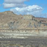
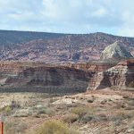
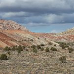
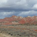
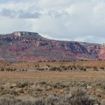
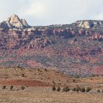
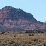
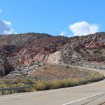
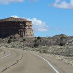
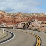
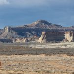
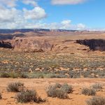
If you want scenery while traveling in Arizona – and Utah now it seems – the highway to take is 89. Sometimes there’s an A at the end, but not today. When we planned this trip, we had no idea that the 2-1/2 hour journey from Bryce to Page would be so scenic, but it didn’t take long to realize that we hit the motherload!
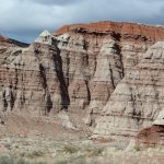
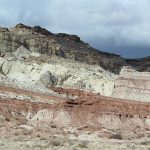
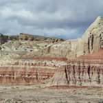
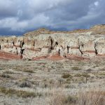
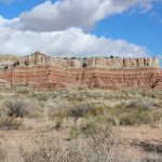
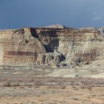
Today’s route takes us along the southern edge of the Grand Staircase–Escalante National Monument, where colorful sandstone cliffs stretch for miles, and wide shoulders and turnouts provide fabulous photo opportunities.
Note: The All-American Road Scenic Byway 12 is a road trip in itself, and will take you east out of Bryce for a more in-depth visit of the Monument. Although the Grand Staircase is spectacular, “the Escalante Canyons section is the most popular area of the monument, especially among hikers. Active waterfalls, arches, riparian oases, sculpted slickrock and narrow canyons are part of the appeal of hikes through the Escalante’s backcountry.”
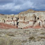
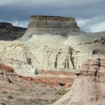
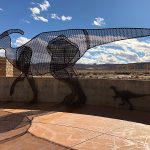
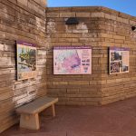
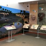
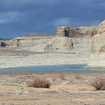
About two hours down the road, Big Water Visitor Center called our name, which turned out to be a wonderful stop. Had our grandchildren been in tow, it would have been even better, since the dinosaur exhibit was fantastic! Turns out, there are three other visitor centers in the Grand Staircase Escalante National Monument, and each have a different theme.
“The Big Water center focuses on the geologic and paleontological discoveries in this region. There is a mural covering one entire side of the center that shows what the dinosaurs and their habitats would have looked like back then.” READ MORE
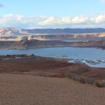
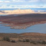
Just down the road we pulled over again. With a name like Lone Rock Beach, we just had to check it out. Surrounded by bright blue waters and poised in front of a gorgeous mountain range, I’m sure glad we took a look. Although just over the border in Utah, it turns out my Arizona cousins loved camping here back in the day, and I can see why!
“Looking out of your tent in the morning at this impeccable campground, a massive, monolithic rock, the Lone Rock, dominates your view of Lake Powell. This free-standing sandstone rock is the namesake of one of the most popular beaches in the Glen Canyon National Recreation Area. The popularity is due largely to the fact that it is one of the few spots that you can drive directly to the water’s edge and camp on the shoreline.
While camping at Lone Rock Campground, be sure to swim in the crystal blue waters. You can also boat — both motorized and human-powered — or enjoy the only designated ATV area in Glen Canyon. Lone Rock Beach Campground is located on Utah Highway 89, two miles south of Big Water, Utah, and 12 miles north of Page, Ariz.” – READ MORE
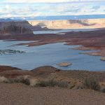
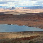
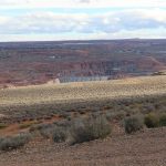
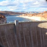
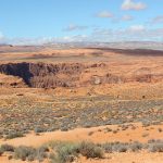
This brings us to Wahweap Overlook, a beautiful vista with a great overview of the land, with Lake Powell in the foreground and the mountains in the distance. It was quite windy and chilly from this vantage point, but the views were spectacular – from the western edge of Lake Powell to the Glen Canyon Dam.
“The vast, rugged landscapes of Glen Canyon National Recreation Area provide an unparalleled spectrum of diverse land- and water-based recreational opportunities for visitors of wide-ranging interests and abilities.” – Read more at the link.
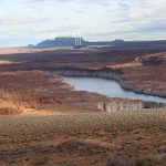
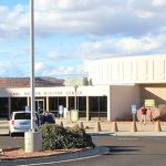
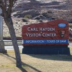
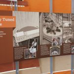
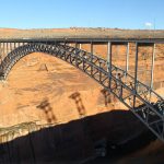
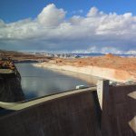
Next stop was the Glen Canyon Dam. Although the tour was closed due to construction, we saw a great movie and checked out the fabulous Visitor Center which had a birds-eye view of the dam and the bridge that spans Glen Canyon. The VC was loaded with great info about the building of the bridge and its importance in the grand scheme of things in the southwest.
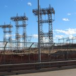
“Glen Canyon Dam, rising 710 feet above bedrock within the steep, rust-colored sand-stone walls of Glen Canyon, was constructed to harness the power of the Colorado River in order to provide for the water and power needs of millions of people in the West.
Glen Canyon Dam is the second highest concrete-arch dam in the United States, second only to Hoover Dam which stands at 726 feet. The 26.2 million acre-feet of water storage capacity in Lake Powell, created by Glen Canyon Dam, serves as a ‘bank account’ of water that is drawn on in times of drought. This stored water has made it possible to successfully weather extended dry periods by sustaining the needs of cities, industries, and agriculture throughout the West.” – READ MORE
Click here for the blog which includes our Hoover Dam visit.
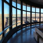
The VC jets out over the canyon a ways for stunning views. Although Jim didn’t stand too close, I found it just wonderful.
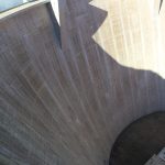
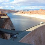
Unlike the bridge that spans the Colorado River near the Hoover Dam, the Glen Canyon Dam Bridge isn’t overly intimidating, so I went halfway across to check out the views. It was cool to be out there, and although the chain link fence caused a little distraction, it did add a sense of security. Traffic was light and only moving at 25mph, but it still made me a little uneasy feeling the movement of the cars on the bridge.
There was a break in the barrier so I could walk to the other side and see more of the canyon walls in the “after-the-dam” photo below. It was a little sad to see such mighty river dwindled down to such a low level.
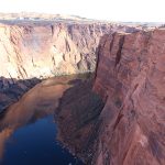
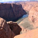
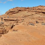
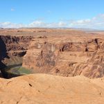
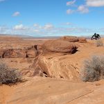
Horseshoe Bend was our last visit in this area. Winter was construction season most everywhere else we went, and this stop was no exception. The main parking lot was closed and we parked in a open area down the road where shuttle buses were staged. For $10 we could park and get a ride to the entrance and back, with just a short wait between shuttles.
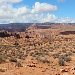
From a distance, it was hard to imagine that there was a canyon anywhere around here, but as we got closer a few indentations in the landscaping came into view.
This morning started out chilly, but we shucked our jackets almost immediately as the ups and downs of the hilly landscape heated us up. Benches strategically placed along the way came in handy a couple of times, and even though our trek was only about a mile down that dusty path (and back), it seemed longer. The construction and the long and unexciting trail coming out added to the “I wish this was over” thoughts in my head.
We had heard that a visit too late in the day would bring a lot of shadows, but during our visit the sun was almost too bright which washed out the photos a bit. Next visit, we may come early in the morning? I guess it’s all just the luck of the draw.
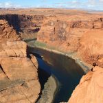
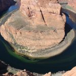
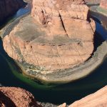
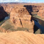
It is quite amazing to think about the power of water and how this amazing river could make a turn like this without human intervention. Wikipedia calls it an incised meander, and you are welcome to check it out here. I just think it’s awesome.
There was another beautiful area with views but as I walked over towards it, I could tell that the vertical sides of the canyon would prevent any better view than the one we had already seen. It seemed to be the place for folks to have some special time or take dangerous selfies, so I made a U-turn back to Jim.
Apparently they worked feverishly to finish construction before tourist season ramped up, so the new parking lot and a Visitor Center opened in April. Turns out you’ll still have to pay the $10 (per car) but now it’s for the new entrance fee. I’m not sure how big the new lot is, but the website (Horseshoe Bend) warns that once the lot is full, you’ll have to come back later. There are options for tours, etc. that can be reserved at that link and also some fantastic photos taken when the lighting was outstanding. We caught the next shuttle back to our car and headed back to our hotel.
Yesterday we were slightly disappointed as we drove up alongside the Best Western View of Lake Powell Hotel and realized that our hotel was actually next door – with no views of Lake Powell. But the Best Western Plus at Lake Powell was a very nice hotel and probably cheaper since our view was the closed swimming pool. Our room was very clean and spacious for our two-night stay, and we enjoyed an extensive array of options at their free breakfast both mornings.
Our first night here was kind of a blur, after a full day at Bryce followed by several hours on the road. We made sure to make the second night more fun, and after seeing the sights, we relaxed for several hours at the Dam Bar and Grill with a delicious dinner and a couple of beers. We talked about the trip so far, the weather back home, how much we’re starting to miss home, and our much-anticipated visit tomorrow – back in Utah. OMGosh, I love road trips!
Next up: The View of The Mittens
Happy trails,
Barb


